Looking for a St. Thomas cruise port map? Good news: it is simpler than it looks. Ships dock at one of two spots on the south side of the island, Havensight (the WICO dock) or Crown Bay, and both sit within a short taxi ride of downtown Charlotte Amalie. This guide gives you a plain-English St. Thomas cruise port map so you know where you land, where everything is, and how to get up to Blackbeard’s Castle before your ship leaves.
St. Thomas Cruise Port Map at a Glance
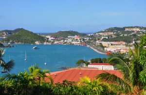
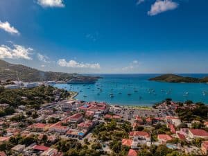
Picture the harbor as a wide bowl with downtown Charlotte Amalie at the center. Havensight is on the east side of the harbor, Crown Bay is on the west side, and the historic downtown and waterfront shops sit between them. Blackbeard’s Castle sits on the hill above downtown, with the harbor views stretching out below.
| Dock | Where it is | Good to know |
|---|---|---|
| Havensight (WICO) | East side of the harbor, a short drive from downtown | Shops and restaurants at the dock, the Paradise Point Skyride nearby, taxis lined up at the gate |
| Crown Bay | West side of the harbor, near the marina | Smaller terminal, taxis and open-air safari buses outside, a bit farther from downtown |
| Downtown Charlotte Amalie | Between the two docks, on the waterfront | Duty-free shopping, Fort Christian, and the base of the 99 Steps |

Havensight (WICO) Dock
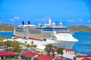
Havensight is the bigger of the two and handles most of the large ships. You walk off the pier straight into a small shopping and dining area, and taxis wait right outside. If you only have a few hours, this is the easy one: you can be in downtown Charlotte Amalie in a short ride. The Paradise Point Skyride is also close by, and we wrote a full guide on Paradise Point if the views are your thing.
Crown Bay Dock
Crown Bay is the second cruise terminal, on the western side of the harbor. It is a smaller, calmer setup, and it often hosts the mid-size ships. There is less to do right at the dock, so most people head straight out by taxi or safari bus. It sits a little farther from downtown than Havensight, so give yourself a few extra minutes on the way back.
How to Get From Either Dock to Downtown
Taxis are the standard way around St. Thomas, and they run from both docks. Fares are set by the territory and posted on a card, and most rides to downtown are quick. We broke down the real numbers in our St. Thomas taxi rates guide, so you will not be guessing at the curb. Open-air safari buses also run along the main roads if you want to share a ride.
Walking from Havensight to downtown is possible for some people, but it is hot, there are hills, and it eats time you could spend on the island. Most cruise visitors take a taxi at least one way.
Finding Blackbeard’s Castle on the Map
Blackbeard’s Castle sits at the top of Charlotte Amalie, at 1001 Blackbeard’s Hill. It is built around Skytsborg Tower, constructed by the Danes in 1679 and one of five National Historic Landmarks in the U.S. Virgin Islands. From downtown you can climb the historic 99 Steps, or take a taxi up and skip the climb.
Once you arrive, here is how it works:
- Jolly Roger’s Restaurant & Pirate Bar is free to walk into. Grab lunch or a rum drink by the pool with a harbor view.
- The $15 day pass covers the castle grounds, a tour of Skytsborg Tower, and a rum room sampling. You can grab it at our ticket page.
- Kids under 10 are free, and USVI residents get in free with island ID.
- We are open 9am to 9pm every day.
Want turn-by-turn help? Our guide on getting from the cruise port to Blackbeard’s Castle walks you through both docks step by step.
A Simple Plan Using the St. Thomas Cruise Port Map
Here is an easy way to use the map if you have a half day:
- Take a taxi from your dock up to Blackbeard’s Castle.
- Do the Skytsborg Tower tour and enjoy the view over the harbor, where your ship is parked.
- Have lunch at Jolly Roger’s.
- Head down toward the waterfront for shopping and Fort Christian.
- Taxi back to the dock with a comfortable buffer before all-aboard time.
If you want a fuller plan, see our St. Thomas itinerary for a cruise day, or check which ships are in port on our cruise ship schedule page.
Tips for Using Your St. Thomas Cruise Port Map
- Know your dock before you leave the ship. Havensight and Crown Bay are not the same distance from town, and your taxi driver will ask.
- Watch the clock. All-aboard is usually 30 minutes before departure. Build in time for traffic on the way back.
- Bring small bills. Taxis take U.S. dollars, the local currency here.
- Wear comfortable shoes. The island is hilly, and the 99 Steps are real.
- Check official port information. The Virgin Islands Port Authority publishes dock details and updates.
St. Thomas Cruise Port Map: FAQ
Which dock is closer to Charlotte Amalie, Havensight or Crown Bay?
Havensight is generally the closer and easier of the two to downtown. Crown Bay is a bit farther out on the west side, but both are a short taxi ride.
Is there a St. Thomas cruise port map I can print?
The simple version is above: Havensight on the east, Crown Bay on the west, downtown in the middle, and Blackbeard’s Castle on the hill. Your ship’s port talk or the Virgin Islands Port Authority also has official maps.
Can I walk from the cruise port to Blackbeard’s Castle?
You can climb the 99 Steps from downtown, but most visitors take a taxi from the dock to save time and energy, especially in the heat.
Does Blackbeard’s Castle cost money to visit?
Jolly Roger’s is free to walk into. The castle day pass is $15 and covers the grounds, the Skytsborg Tower tour, and a rum room sampling.
Is there a place to stay near the cruise port?
Our hotel is on the castle grounds, with rooms looking out over Charlotte Amalie Harbor. Reservations are open.
Ready to Head Up the Hill?
Now that you know the layout, the best view on the whole map is waiting at the top. Grab your $15 day pass, or just walk into Jolly Roger’s for lunch and a harbor sunset. See you at the castle.